Seismic Hazard analysis in the Philippines using earthquake occurrence data:
The seismic hazard in the Philippines is evaluated from historical earthquake data using a new computer program called the Seismic Hazard Mapping Program (H-MaP). The seismic hazard is given in terms of the expected peak ground acceleration and the expected acceleration response spectrum. Regions of high seismic hazard are identified. These include Central Luzon which suffered heavy damage during the July 16, 1990 earthquake. The design levels of the seismic force of the Philippines are compared with those of the Japan and are found to be considerably lower. Long period structures are found to be more vulnerable to damage. The collection of strong ground motion records from Philippine earthquakes is necessary for more realistic design level for the Philippines. From the seismic hazard maps, a seismic zoning map based on the expected maximum accelerations is proposed.
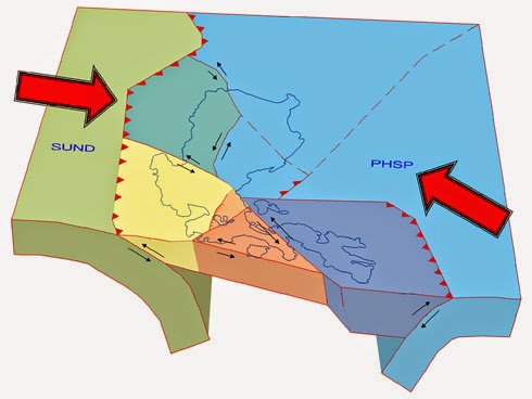
This figure shows a tectonic model of the northern Philippine island arc, based on seismicity, earthquake focal mechanisms, GPS measurements, and satellite imagery. The island arc lithosphere is modeled as a series of elastic blocks, which accommodate large-scale tectonic motions between the Philippine Sea Plate (PHSP) and the Sundaland Block of Eurasia (SUND). The major plate motion is accommodated by deformation along a series of arc-bounding and intra-arc faults that accumulate elastic strain between major earthquakes
The 7.2 magnitude earthquake on 15 October 2013 was the strongest to hit the Philippines' Bohol island province in nearly 25 years, and occurred on a previously unknown fault line. Municipalities in the northwest of Bohol were hardest hit. The total number of affected people has been adjusted to 1.3 million from an initial estimate of 3.2 million as 2 million people from Cebu were first included, but later assessments identified that the island was not affected by the earthquake. According to government assessments and figures from early January, the earthquake damaged in total 79,217 houses out of which 13,402 were destroyed. The Bohol Earthquake Action Plan (BEAP) was issued on 25 Oct, requesting $46.8 million. A revised version was launched in January, reducing the requested amount to $33.8 million in line with the outstanding needs. (OCHA, 6 Feb 2014)
Highlights
The priority remaining needs are shelter, early recovery and support to health services.
This revised action plan seeks US$33.8 million over a six-month period from October 2013 to April 2014.1 The current funding gap is $19 million.
WASH facilities are still needed in evacuation camps, schools and health facilities.
Accurate information on IDPs to effectively allocate funds and develop a comprehensive resettlement strategy will soon be finalized.
13 new projects in the revised action plan that include local partners.
Philippines:BoholEarthquakeActionPlan(Revised)January2014:http://reliefweb.int/sites/reliefweb.int/files/resources/Bohol%20Earthquake%20Action%20Plan%20%28BEAP%29%20Revision%20FINAL.pdf
Reference: http://www.iitk.ac.in/nicee/wcee/article/10_vol10_6031.pdf
The fact that we still have areas with unknown faults that can provoke a quake is a bit scary (the 1994 Northridge quake started at a blind fault in South CA). So much to be done...
ReplyDelete